Ӳкерчĕк:Martinique legende arrs.PNG
Пысăкрах калăпăшли çук.
Martinique_legende_arrs.PNG ((419 × 478 пиксел, файл пысăкăше: 16 Кб, MIME-тĕсĕ: image/png))
Кĕскен ăнлантарни
| Ӑнлантарни |
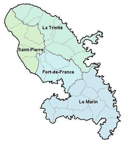
Carte de la Martinique avec ses 4 arrondissements. Map of French department of Martinique with its 4 "arrondissements". |
| Дата | 2 Кӑрлач уйӑхӗн 2007 (дата первоначальной загрузки файла на вики) |
| Ҫӑлкуҫ | No machine-readable source provided. Own work assumed (based on copyright claims). |
| Автор | No machine-readable author provided. BigonL assumed (based on copyright claims). |
Лицензилени
| Я, владелец авторских прав на это произведение, передаю его в общественное достояние. Это разрешение действует по всему миру. В некоторых странах это не может быть возможно юридически, в таком случае: Я даю право кому угодно использовать данное произведение в любых целях без каких-либо условий, за исключением таких условий, которые требуются по закону. |
Файл историйĕ
Вӑхӑт ҫине пуссан, ун чухнехи версине пӑхма пулать.
| Дата/Вăхăт | Миниатюра | Калӑпӑш | Хутшăнакан | Асăрхав | |
|---|---|---|---|---|---|
| хальхи | 16:48, 2 Кӑрлач уйӑхӗн 2007 | | 419 × 478 (16 Кб) | BigonL | Carte de la Martinique avec ses 4 arrondissements. Map of French department of Martinique with its 4 "arrondissements". |
Файлпа усă курни
Ку файлпа ҫак 1 страницӑра усӑ курнӑ:
Файлпа глобаллӑ усӑ курасси
Ку файлпа ҫак викисенче усӑ курнӑ:
- cs.wikipedia.org усӑ курасси
- el.wikipedia.org усӑ курасси
- en.wikipedia.org усӑ курасси
- es.wikipedia.org усӑ курасси
- fa.wikipedia.org усӑ курасси
- fr.wikipedia.org усӑ курасси
- gl.wikipedia.org усӑ курасси
- is.wikipedia.org усӑ курасси
- it.wikipedia.org усӑ курасси
- ka.wikipedia.org усӑ курасси
- lb.wikipedia.org усӑ курасси
- mk.wikipedia.org усӑ курасси
- oc.wikipedia.org усӑ курасси
- Fort-de-France
- Comunas de Martinica
- Modèl:Comunas de Martinica
- L'Ajoupa-Bouillon
- Les Anses-d'Arlet
- Basse-Pointe
- Le Carbet
- Case-Pilote
- Le Diamant
- Ducos
- Fonds-Saint-Denis
- Le François
- Grand'Rivière
- Gros-Morne
- Le Lamentin
- Le Lorrain
- Macouba
- Le Marigot
- Le Marin
- Le Morne-Rouge
- Le Prêcheur
- Rivière-Pilote
- Rivière-Salée
- Le Robert
- Saint-Esprit
- Saint-Joseph (Martinica)
- Saint-Pierre (Martinica)
- Sainte-Luce (Martinica)
- Schœlcher
- La Trinité
- Les Trois-Îlets
- Le Vauclin
- Le Morne-Vert
- Bellefontaine (Martinica)
- Sainte-Marie (Martinica)
- Sainte-Anne (Martinica)
- pl.wikipedia.org усӑ курасси
Ку файлпа глобальлӗ епле усӑ курнине пӑх.